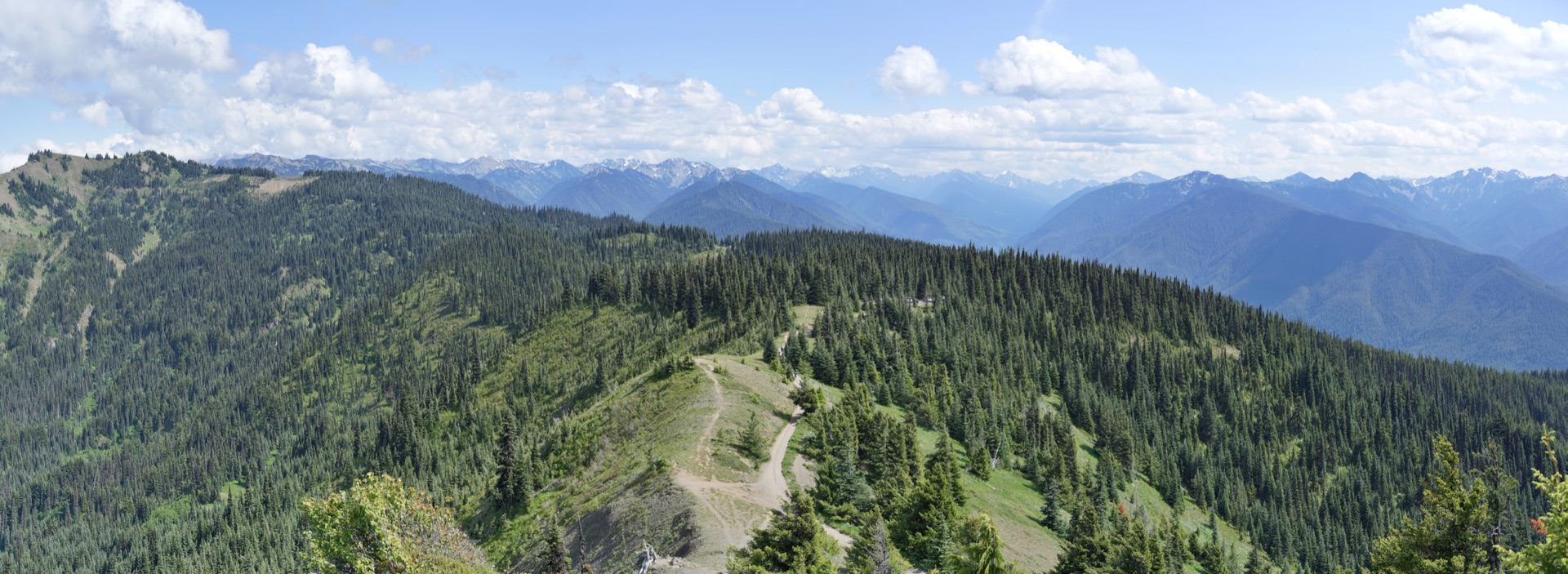
You drive 17 miles of switchbacks out of Port Angeles, climbing steadily through Douglas fir and western hemlock until the trees thin and the road levels off at 5,230 feet. On a July morning the main parking lot fills before 9am. The reason is obvious the moment you step out: the Olympic Mountains rise to the south, glaciated and stacked close, and the Strait of Juan de Fuca shines far below to the north. It is one of the most striking roadside viewpoints in Washington.
Most visitors spend their time on the Hurricane Ridge Visitor Center deck and drive back down. But Hurricane Ridge hiking is the actual point of coming here. From a paved half-mile meadow loop to an exposed ridgeline summit with views stretching to the San Juan Islands, the trails here reward anyone willing to lace up and walk. This guide covers every option, from the easiest stroll to the most demanding full-day route.
Before You Hike: Permits, Parking, and Timing
Hurricane Ridge requires timed entry permits during peak season, roughly mid-June through Labor Day weekend. Permits are issued for 30-minute arrival windows and must be reserved in advance at recreation.gov. They release 30 days ahead and typically sell out within hours. The reliable strategy: set a calendar alert for 7am Pacific on your 30-day-out date and be online the moment permits go live.
Outside the permit window, which includes most of September and October and the entire period before mid-June, you can drive up without a reservation. Early September is a strong window. Permit requirements have expired, crowds drop by 30 to 40 percent compared to August, fall color appears on the blueberry shrubs and vine maple, and the late-summer clarity that defines the Olympic Peninsula continues.
Parking: The main lot at the visitor center holds a few hundred vehicles and fills by mid-morning on summer weekends. With a timed entry permit, your arrival window functions as a de facto parking reservation. Without one, arriving before 8am or after 4pm is the only dependable way to find a space on a Saturday in July or August.
Road hours and access: Hurricane Ridge Road operates on a published schedule maintained by the park. During peak summer, the road typically opens at 7am and closes at 8pm. Hours contract in shoulder seasons, and the road closes entirely during high winds and active snow removal. The Olympic National Park road conditions page is the authoritative source before you leave home, especially in May or any time after October.
Season window: July through September is when every trail is snow-free and conditions are reliable. At 5,200 feet, snow patches persist into late June and can cover upper sections of Hurricane Hill Trail. The wildflower peak on the meadows runs mid-July through early August: subalpine lupine, Indian paintbrush, bear grass, and spreading phlox. It is worth timing a visit to overlap with bloom if you can.
Meadow Loop Trail: Easy, Paved, and Worth Your Time (0.5 Miles)
The Meadow Loop Trail starts immediately outside the visitor center and circles through the subalpine meadows that define the upper ridge. It is half a mile, partially paved, with minimal elevation change. It takes about 20 minutes at a casual pace.
What makes it worth doing even if you are only stopping for an hour: Olympic marmots. These animals (Marmota olympus) exist nowhere else on Earth. They are notably larger than the hoary marmots found in the Cascades and completely unbothered by people, often feeding within 10 to 15 feet of the trail. Children find them captivating. The rule is clear: no feeding. Handout food disrupts their foraging behavior and compromises their ability to build the fat reserves they need for hibernation.
Columbian black-tailed deer are a near-constant presence on the loop as well. They graze through the meadows throughout the day and have adapted over decades to the foot traffic on the trail, often crossing within arm’s reach. Watch them, keep your distance, and do not attempt to pet them regardless of how approachable they appear.
The Meadow Loop is the right option for families with young children, visitors with mobility limitations, or anyone who came primarily for the viewpoint and wants a short walk to round out the stop. The views from the loop are nearly identical to those from the visitor center deck.
Hurricane Hill Trail: The Hike Worth the Drive (3.2 Miles Round Trip)
For anyone capable of a moderate half-day hike, Hurricane Hill Trail is the defining experience at Hurricane Ridge. It’s an out-and-back trail that climbs from the visitor center parking lot to the summit of Hurricane Hill at 5,757 feet, with open views in every direction from the top.
Distance: 3.2 miles round trip. Elevation gain: approximately 700 feet, distributed across rolling ridgeline terrain with some short descents and re-ascents. Difficulty: Moderate. The grade is consistent but never steep. The primary challenges are sun exposure on a trail with almost no shade, and wind on the exposed upper section approaching the summit.
The trail runs west along the ridge from the visitor center, passing through open meadow on both the north and south faces of the ridge. The north face drops into old-growth forest 3,000 feet below; the south face frames glaciated Olympic peaks at near-eye level. On clear days you can see the Strait of Juan de Fuca, the San Juan Islands to the northeast, and, given enough visibility, the southern flank of Vancouver Island. On exceptionally clear days in late summer, Mount Baker appears above the North Cascades skyline roughly 90 miles to the east.
The summit of Hurricane Hill is a broad rocky viewpoint with room to spread out and eat lunch. Do not confuse it with the false summit you reach about two-thirds of the way up, where many hikers turn around. The actual summit is another 10 to 15 minutes past the false top, and the view improvement is significant.
Allow two to three hours round trip at a comfortable pace. Bring at least two liters of water per person: there are no water sources on the trail or near the trailhead. The trail runs under direct sun for most of its length, so a hat, sunscreen, and sunglasses are not optional in summer. Bring a wind layer for the exposed summit approach. If you leave it in the car, you will want it.
Parking note: The Hurricane Hill trailhead uses the same main parking lot as the visitor center. No separate trailhead lot. All the advice about early arrival applies here.
High Ridge Trail: A Quieter Walk Along the Crest
Running east from the visitor center along the top of the ridge, the High Ridge Trail offers a good extension or alternative for visitors who want more walking without committing to the full Hurricane Hill climb. The trail follows the open ridgecrest through meadow terrain, with views similar to Hurricane Hill on the north-south axis.
This route sees fewer hikers than Hurricane Hill, partly because it lacks a defined summit payoff. For those who prefer to walk and look rather than climb to a peak, it is the better choice. The meadows along the crest are good habitat for Olympic marmots and the raptors that hunt them: red-tailed hawks and sharp-shinned hawks patrol the updrafts along the cliff faces consistently throughout the day.
The High Ridge Trail also serves as an access route to connecting trails that descend toward the valley floor. If you’re building a longer loop, the trail makes sense as a component. For a casual out-and-back, most hikers turn around when the views level off or when they’ve had enough.
Obstruction Point: For Serious Hikers Only
Eight miles east of the visitor center, at the end of an unpaved, single-lane road with no turnarounds suitable for RVs or trailers, lies Obstruction Point at 6,150 feet. This is the highest point accessible by vehicle anywhere in Olympic National Park and the starting point for the park’s most remote ridge hiking.
From the Obstruction Point trailhead, the Grand Ridge Trail runs east along a narrow, exposed ridgeline toward Deer Park, approximately 7.5 miles one-way. There are no facilities at either end or along the route, water sources require treatment and are limited, and the terrain demands solid navigation skills. This is not a trail for beginners.
What you get in exchange: a ridgeline walk that very few people complete, views that extend across the entire northern Olympic range, and the particular silence of a corner of the park that sees almost no casual foot traffic.
The Obstruction Point Road is unpaved, single-lane, and not maintained for early opening: it remains snow-covered through late July most years. Before driving out, call the Olympic National Park Visitor Center in Port Angeles to confirm current road conditions. The road closes at the first significant fall snowfall, often by early October.
If you’ve completed Hurricane Hill and want more, Obstruction Point is the logical next step on a future visit. The two are different enough in character and difficulty that they’re worth separate days.
Wildlife Across All the Trails
Olympic marmots are visible on every trail at Hurricane Ridge, with the Meadow Loop and the lower section of Hurricane Hill most reliable for close encounters. They’re most active from mid-morning through early afternoon, less so during the heat of late afternoon. You’ll hear their alarm whistle before you see them: a sharp, single note when a hawk crosses overhead.
Roosevelt elk move through the upper meadows, most commonly at dawn and dusk. They are large animals: a mature bull stands five feet at the shoulder. Give them considerable space on the trail, and never place yourself between a cow and her calf in early summer.
Sooty grouse (also called blue grouse) are common in the subalpine transition zone just below the main meadow and routinely flush from the brush a few feet from the trail. The startle is immediate and loud; they are not dangerous.
Black bears are present in Olympic National Park at lower elevations and occasionally travel above treeline in summer, particularly as berry crops ripen in August and September. Carry food in a bear canister or bear-resistant container if you’re on a longer route like Grand Ridge. On the Meadow Loop or Hurricane Hill, the risk is low but food storage discipline is still good practice.
What to Bring and the Best Time to Go
Best months: Mid-July through September. August is peak bloom and peak crowds. September offers comparable weather, shorter lines, and the beginning of fall color in the lower subalpine shrubs.
Gear for any trail:
- Water (2+ liters per person; no sources on any trail)
- Sun protection: hat, SPF 30+, sunglasses
- Wind layer for the exposed ridge
- Sturdy trail shoes (the Meadow Loop aside, trails are rocky and uneven)
- Snacks if you’re on Hurricane Hill or longer
After the hike: The visitor center has interpretive displays covering the endemic species and the park’s glacial geology. Port Angeles is 30 to 40 minutes down the mountain with restaurants and lodging for every budget. For those who want to spend more than a day in the park, camping in Olympic National Park covers the best campgrounds across all zones.
Hurricane Ridge is one strong anchor for a longer trip. The Olympic Peninsula road trip covers the full circuit: rainforest valleys, wild Pacific coast, hot springs, and the northern mountain access point at Hurricane Ridge. If you want a complete picture of all the park’s zones before you plan your specific days, things to do in Olympic National Park is the right starting read. For hikers comparing routes across the entire peninsula, hiking the Olympic Peninsula puts Hurricane Ridge in context alongside the Hoh River Trail, the Enchanted Valley, and the coast walks.
Hurricane Ridge is where most first-time visitors grasp the full scale of the Olympic Mountains. The hikes are what make it more than a viewpoint.
Hero photo: Hurricane Ridge panorama by Dllu, licensed CC BY-SA 4.0, via Wikimedia Commons. Resized.