National Park
Olympic National Park
Three wildly different worlds, one unforgettable peninsula
Established
1938
Size
922,650 acres — nearly as large as Rhode Island, spanning the entire Olympic Peninsula
Elevation
Sea level to 7,980 feet (Mount Olympus)
Annual Visitors
Approximately 3 million
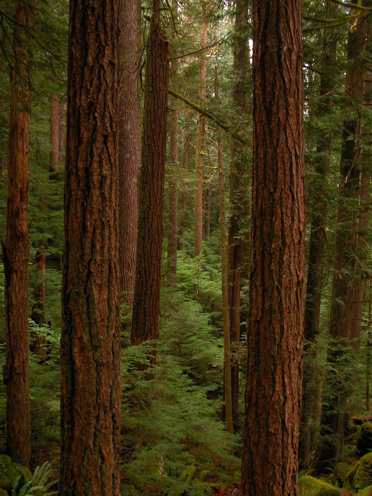
Olympic National Park is a masterclass in ecological diversity compressed into a single landscape. The park's geography is its defining feature: the Olympic Mountains sit like a fortress in the center, creating a rain shadow so dramatic that west-facing valleys receive up to 170 inches of annual precipitation while areas just 30 miles east get less than 20 inches. This extreme variation has created three entirely separate worlds. On the western slopes, the Hoh, Quinault, and Queets valleys nurture the largest intact temperate rainforest in the lower 48 states — a primordial landscape where 500-year-old Sitka spruce trees tower 200 feet overhead, their trunks wrapped in moss so thick it muffles sound and transforms the forest into something otherworldly. Rising above the rainforest are the glaciated alpine reaches, with Mount Olympus anchoring the range at 7,980 feet, its crown of year-round ice visible from the rainforest floor below. And wrapping around the peninsula's western edge is over 70 miles of largely undeveloped Pacific coastline, where dramatic sea stacks pierce the surf and tide pools teem with starfish, anemones, and urchins that rival any aquarium. The park's isolation on the Olympic Peninsula and its range of elevations have allowed species to evolve found nowhere else on Earth, earning it designation as a UNESCO World Heritage Site and International Biosphere Reserve. Unlike most national parks, Olympic has no single main road; instead, you access different zones from different sides of the peninsula, making it a park that demands either multiple days or multiple visits to truly comprehend.
Protecting three radically distinct ecosystems — temperate rainforest, alpine peaks, and wild Pacific coastline — within a single park, all shaped by extreme precipitation gradients created by the Olympic Mountains
Quick Info
Must-See Highlights
Hoh Rain Forest
The park's most iconic ecosystem and utterly unlike anywhere else in North America. The Hall of Mosses Trail (0.8 miles, easy loop) is the must-do — a silent, dripping cathedral of bigleaf maples draped in club moss so thick the trees look airbrushed, with 200-foot Sitka spruce towering overhead. Even on crowded days, the green-filtered light and absolute quiet make it feel primordial. For longer immersion, the Hoh River Trail stretches 17.3 miles upstream through old-growth forest to Blue Glacier on Mount Olympus.
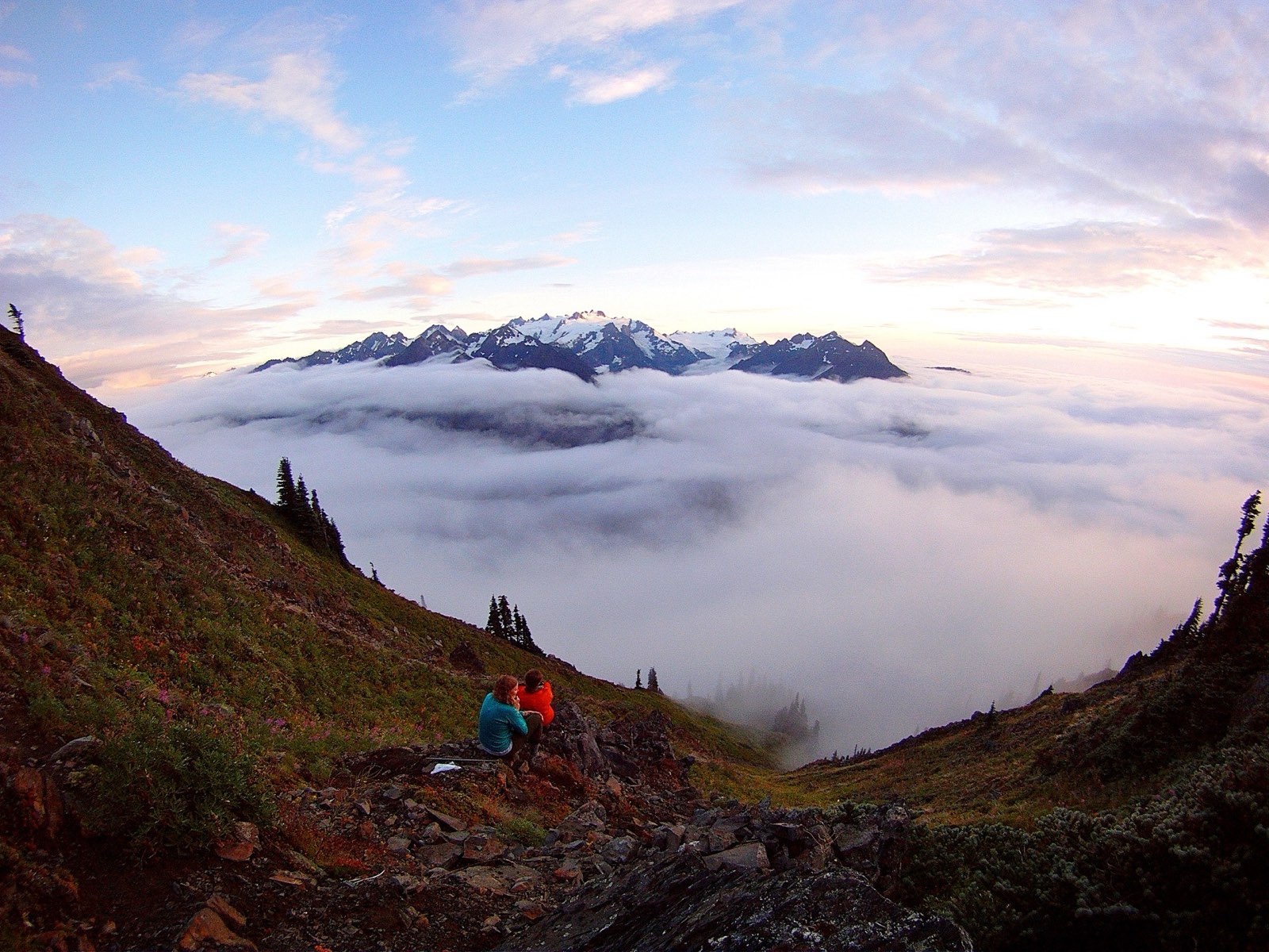
Hurricane Ridge
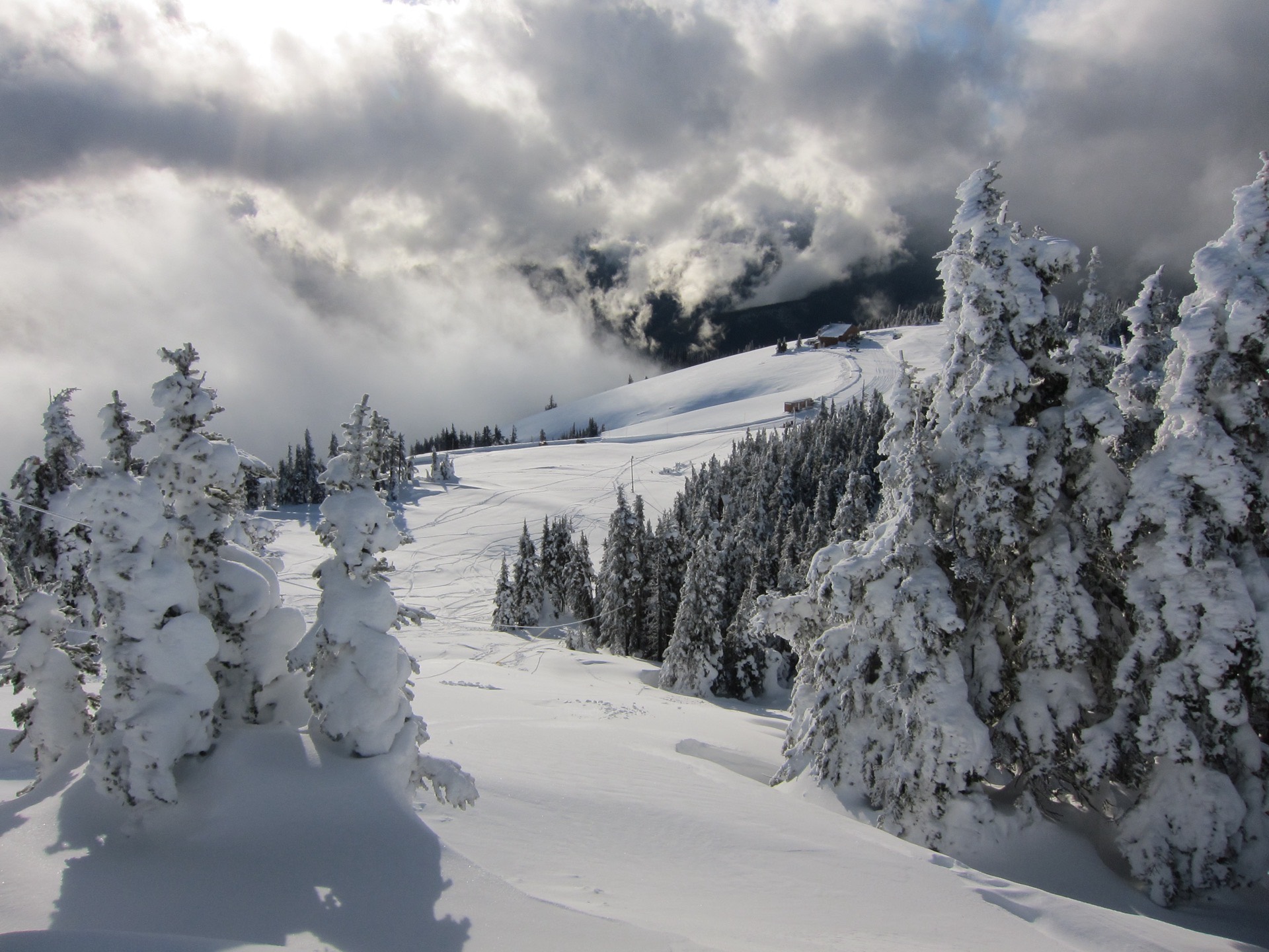
The park's most accessible alpine zone and a 17-mile drive from Port Angeles that climbs 5,000 feet in elevation. On clear days — and they're increasingly rare as maritime clouds rule here — views stretch across the Strait of Juan de Fuca to Vancouver Island and across the park's glaciated peaks. The Hurricane Hill Trail (3.2 miles round trip) extends views along an exposed ridgeline where wildflowers explode in July and August. In winter, a small ski area operates weekends, and the ridge becomes a snowshoeing destination.
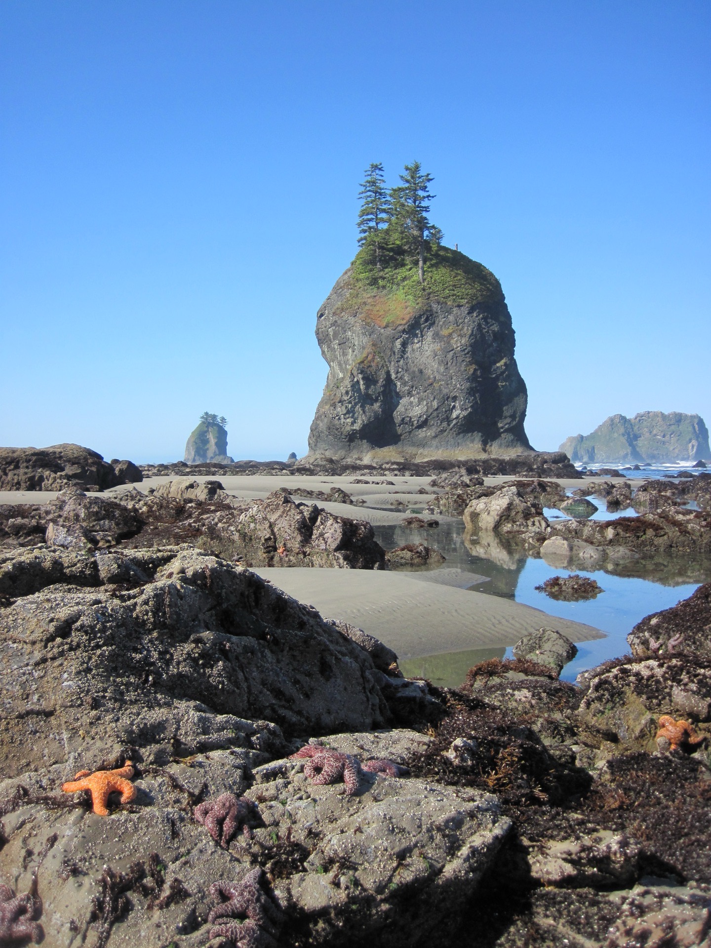
Ruby Beach
The most dramatic and popular coastal access point, where 80-foot sea stacks rise dramatically from the surf and massive driftwood logs line the shore like a giant's game of pick-up sticks. Low tide reveals tide pools packed with sea stars, anemones, and urchins in the rocky outcrops. Visit at sunset when the sea stacks glow orange-red, or explore at low tide (check tide tables) to maximize beach access and tide pool exploration.
Ozette Lake Loop
A rarely-crowded alternative to the popular rainforest trails — a 9.3-mile loop that combines two ancient boardwalk trails through lush coastal forest and ends at Cape Alava, the westernmost point in Washington State with a wild, rocky beach. The trails are flat and well-maintained, making this perfect for families wanting old-growth forest without the Hoh crowds. Bring binoculars for eagle spotting and check tide tables before hiking to the cape.
Elwha River Valley
A hidden gem largely overlooked by tourists — a 5-mile drive from Port Angeles leads to a massive restoration project where two dams were removed, unleashing the river and its salmon runs. The Elwha River Trail stretches 3.2 miles through recovering forest where you'll see young trees reclaiming denuded slopes, native salmon returning after a 100-year absence, and a canyon that's being recarved by the river. It's a powerful lesson in ecological resilience.
Sol Duc Hot Springs
Natural hot springs (130°F) in a remote river valley that have been developed with a historic lodge and bathhouse — the only place in the park where you can soak in warm mineral water surrounded by old-growth forest. Three developed pools (kept at 98-104°F) sit steps from the lodge. The Sol Duc River Trail extends 5.6 miles to scenic Sol Duc Falls, and numerous backcountry trails branch from here into the park's interior.
Quinault Rain Forest Loop
The park's quietest rainforest experience — a 3.8-mile loop around pristine Quinault Lake where you're more likely to see Roosevelt elk and bald eagles than crowds. The trail winds through ancient Sitka spruce and western hemlock, with views across the lake to the glacier-covered peaks beyond. The Quinault Lake Lodge (a historic property) sits on the southern shore, and the northern shore accessed by trail feels truly remote.
Deer Park
A narrow, winding road (not recommended for trailers or RVs) climbs 3,600 feet in 17 miles to a high-elevation meadow with panoramic views south toward Mount Olympus and Hockett Peak. Open only July through September, this is the park's second-highest point and a prime spot for alpine wildflowers and mountain goat viewing. The Obstruction Point Road offers shorter walks and exceptional vistas.
When to Visit
spring
March - May
Spring is subtle and wet — expect frequent rain and gray skies, especially in lower elevations where precipitation continues heavy through May. However, the rainforests come alive with emerging ferns and wildflower seedlings, the Hoh River runs milky and high with snowmelt, and the coast sees fewer visitors. Higher elevations remain snowbound until June, and Hurricane Ridge typically doesn't open until mid-June. Best for: solitude seekers and photographers who love moody, overcast light.
summer
June - September
Peak season and genuinely the park's best weather window — July, August, and September are the driest months with temperatures between 65-75°F. Alpine meadows explode with lupine, paintbrush, and avalanche lily in July and August. Coastal access is ideal, and most trails are snow-free by late July. This is when Hurricane Ridge stays reliably open and the high country becomes accessible. Crowds are heaviest in July and August; visit in early June or September to dodge peak visitation while maintaining good weather odds.
fall
October - November
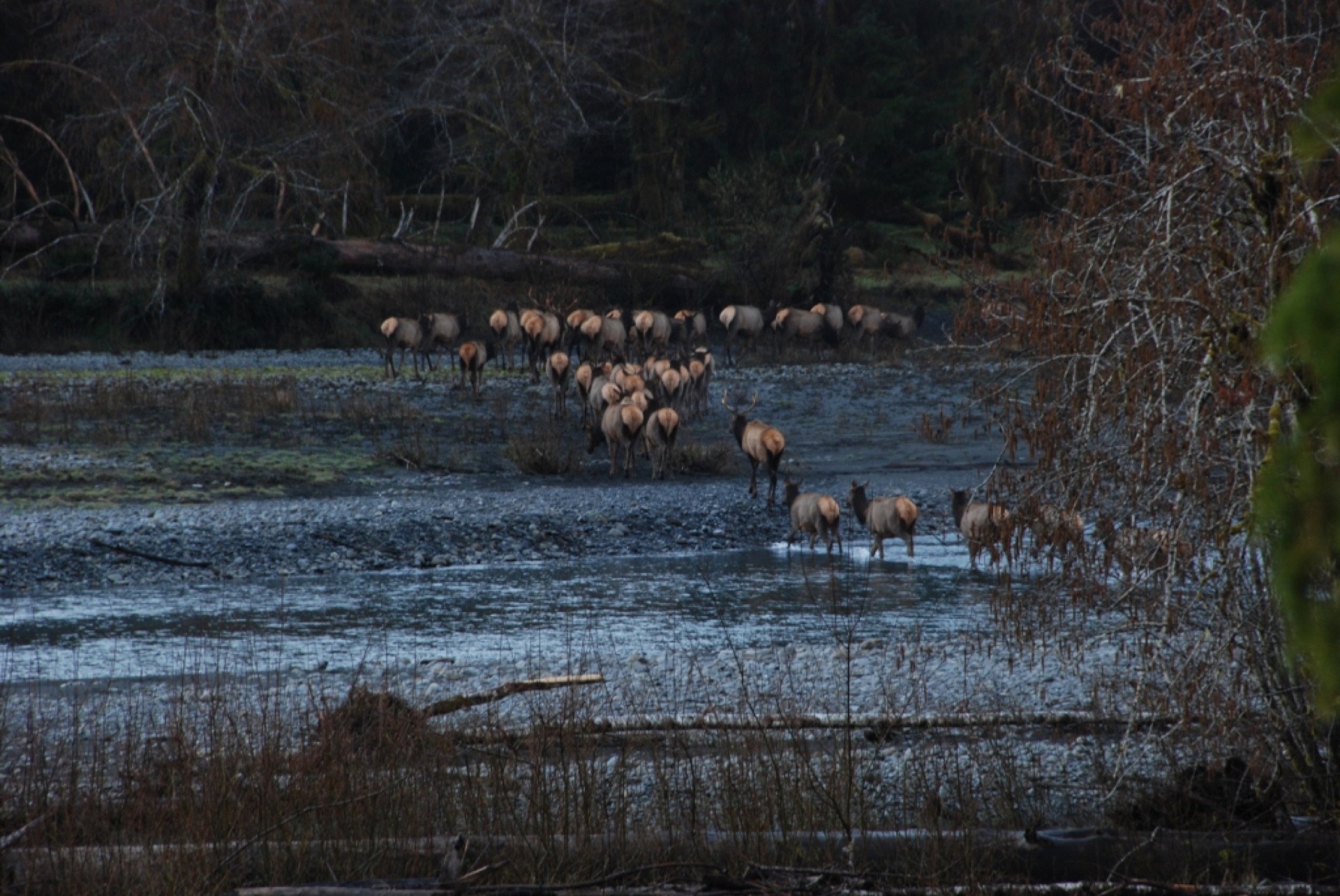
Fall transforms the rainforest into shades of gold and amber, with deciduous bigleaf maples turning brilliant yellow against the evergreen backdrop. Precipitation picks back up in November, but October offers clear, crisp days perfect for hiking without summer crowds. Roosevelt elk begin their rut in early fall, making this prime wildlife viewing season in the Hoh and Quinault valleys. Expect higher water levels in rivers and creeks, and plan on shorter daylight hours.
winter
December - February
Winters are mild at lower elevations (rarely below freezing in the valleys), but the rainforests receive relentless precipitation — expect rain on 70% of days and bring waterproof gear rated for all-day downpours. Higher elevations receive heavy snow; Hurricane Ridge typically closes December through March due to avalanche danger, though it occasionally opens on weekends. The upside: trails are nearly abandoned, Roosevelt elk descend into the valleys from the high country, and the landscape has a raw, windswept beauty. The coast sees dramatic winter storms with huge waves.
Wildlife & Nature
Roosevelt elk are the park's most iconic residents, named for Theodore Roosevelt and found nowhere else — they're larger and darker than Rocky Mountain elk. In the Hoh and Quinault valleys, you'll see them most frequently in fall during the rut (September-October) and in winter when they descend from the high country; dawn hikes in these valleys offer good sighting chances. Mountain goats scramble across the steep alpine ridges, especially visible from Hurricane Ridge in summer. Black bears roam throughout the park but are rarely seen; they're most active in late summer when feeding on berries and salmon. Coastal areas support harbor seals, sea lions, and river otters, while tide pools support colorful sea stars (including the vibrant purple sea urchin), anemones, and chitons. Bald eagles are surprisingly common, especially along the Elwha River and Quinault Lake where salmon runs attract them. The rainforests harbor three salmon species, winter wrens, spotted owls, and marbled murrelets — all species that depend on the old-growth habitat the park protects. Breeding seabirds occupy the coastal rocks, including puffins, cormorants, and murres. Visit in fall and early winter for the best elk viewing, summer for mountain goats and alpine wildflowers alongside wildlife, and spring for migrating raptors and nesting seabirds.
Gallery
Photos courtesy of the National Park Service and Wikimedia Commons
Insider Tips
Skip the Hall of Mosses at midday when tour buses crowd it; hike it at dawn (gate opens around 8 AM) or after 4 PM when the light turns magical and you might have the forest nearly alone. The trail is equally beautiful at either time, but solitude makes it transcendent.
The park has no single main road, so plan your visit around one primary zone — you cannot see all three (rainforest, alpine, coast) in a single day without spending 8+ hours driving. Pick one and go deep: spend a full day in the Hoh, or dedicate time to Hurricane Ridge plus Ozette, or focus on the coast. This prevents disappointment and lets you actually absorb the landscape.
Visit Hurricane Ridge on your last day rather than first — if weather is poor initially, you'll have time to check conditions daily and pick the clearest window. Ridge weather is notoriously unpredictable; afternoon clouds roll in fast, so aim for early morning summits and be flexible with your schedule.
Bring serious rain gear even in summer — the park's precipitation is legendary, and sudden showers can drench you in minutes. Waterproof pants, not just jackets, and a rain cover for your backpack are non-negotiable, even in July. Locals swear by misting rain rather than downpours, but it's relentless.
Check tide tables before visiting the coast — low tide reveals tide pools, beach access extends farther, and the landscape transforms. Some beaches are nearly inaccessible at high tide; a 2-3 hour window of low tide changes everything about your experience at places like Ruby Beach and Cape Alava.
Take the Ozette Lake Loop instead of assuming Hoh is your only rainforest option — it's equally lush, has zero crowds compared to the iconic hall of mosses, and the boardwalk trails allow you to focus on the landscape rather than navigating muddy paths. Add the cape hike for a bonus coastal experience.
Book Sol Duc Hot Springs cabins far in advance (open year-round) for one of the park's most memorable experiences — soaking in natural hot springs surrounded by old-growth forest is otherworldly, and staying overnight means you can hike at sunset and dawn when light is perfect and humans are absent.
Download offline maps and check NPS website before your trip — cell service is virtually non-existent throughout the park, and weather can change fast, making navigation tools essential. The park's geography is complex, and getting lost happens.