National Park
North Cascades National Park
Jagged peaks, 300 glaciers, turquoise alpine solitude
Established
1968
Size
684,000 acres across three National Park Service units — nearly as large as the state of Delaware
Elevation
1,600 feet at Ross Lake to 10,541 feet at Mount Baker
Annual Visitors
Approximately 2 million day visitors; fewer than 40,000 overnight visitors
North Cascades National Park is where the Pacific Northwest's wet, temperate rainforests collide with the dry, fire-adapted forests of the interior — and the mountains themselves are caught in the middle, crowned by 318 glaciers that cling to jagged peaks like jewels in a crown. The park straddles the Cascade crest, creating two distinct ecosystems: the western slopes receive 80+ inches of precipitation annually, feeding old-growth Douglas fir and western hemlock forests so dense that in some valleys you can barely see the sky; the eastern slopes, in the rainshadow, are warmer and drier, with ponderosa pine and larch forests that burn periodically and regenerate from fire. This ecological duality makes North Cascades a living laboratory for how moisture shapes mountains — and how climate change is reshaping them in real time. The park's glaciers have retreated dramatically in the past century; some that were vast in 1900 are now fragmented or gone entirely, making a visit here feel urgent, like witnessing a landscape in transformation. Yet for all this scientific significance, what strikes you most is the raw beauty: turquoise lakes fed by glacial meltwater, granite peaks that rise 5,000 feet from valley floors, waterfalls that thunder down rock faces, and an overwhelming sense of remoteness — you can walk for days here and see no one but other hikers.
The highest concentration of glaciers in the lower 48 states and some of the most rugged, inaccessible alpine terrain in North America
Quick Info
Must-See Highlights
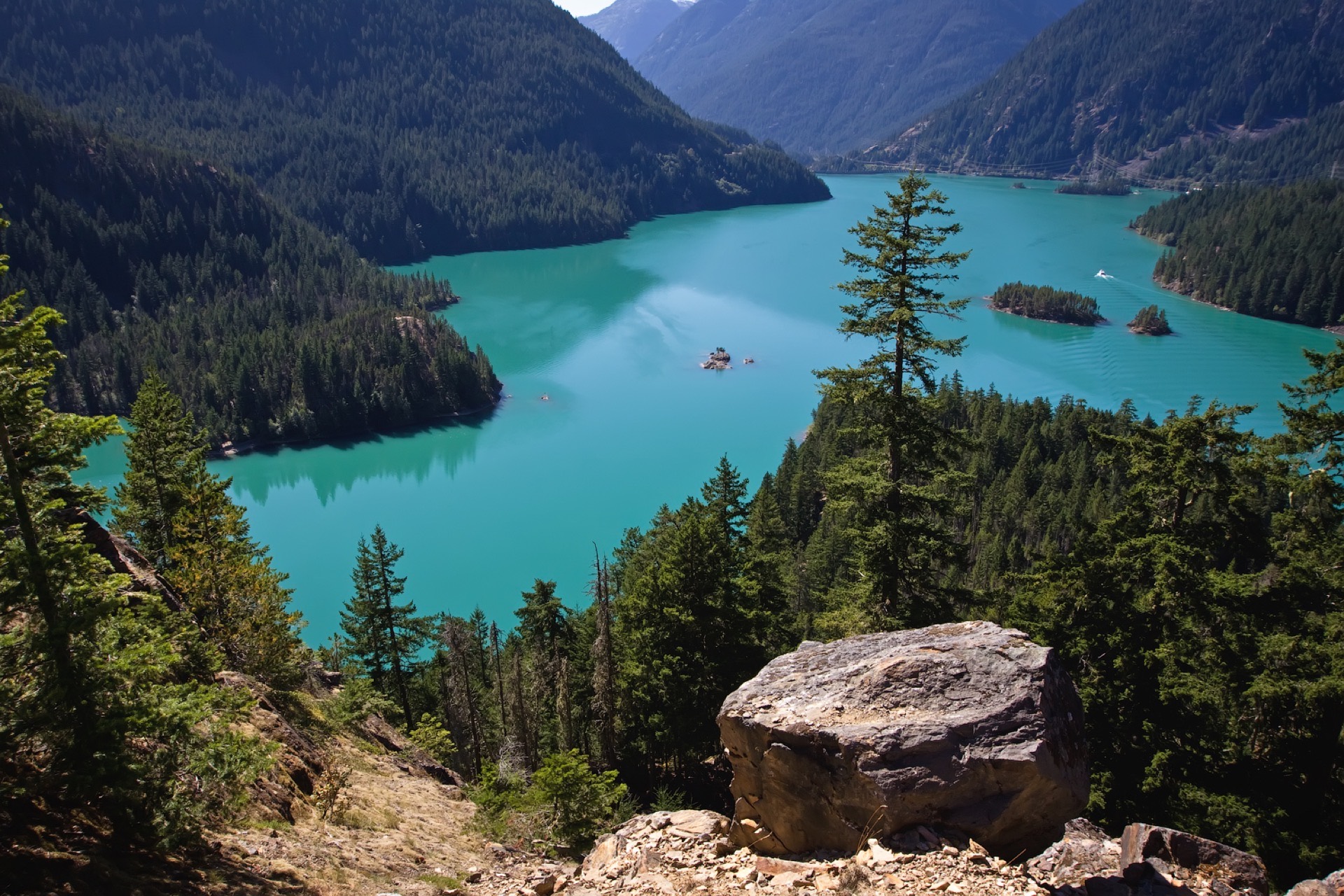
Diablo Lake Overlook
Stop at the pullout on SR-20 (between milepost 126-127) and gaze at the most improbable blue-green water you've ever seen. That color comes from glacial flour suspended in the lake, and it's best viewed in bright midday sun when the turquoise pops against dark forested ridges. It's a 10-second stop that will make you gasp — and the three peaks reflected in the water are Colonial, Pyramid, and Snowfield.
Cascade Pass Trail
A 7.4-mile round-trip hike (3,700 feet elevation gain) that feels like you're climbing into the sky itself. The trail switchbacks through subalpine meadows, past Cascade Lake, and tops out at 5,401 feet with a 360-degree view of granite peaks, cascading water, and distant glaciers. On clear days, you can see Mount Rainier to the south and Mount Baker to the north. Go in mid-August when the meadow wildflowers are at their absolute peak.
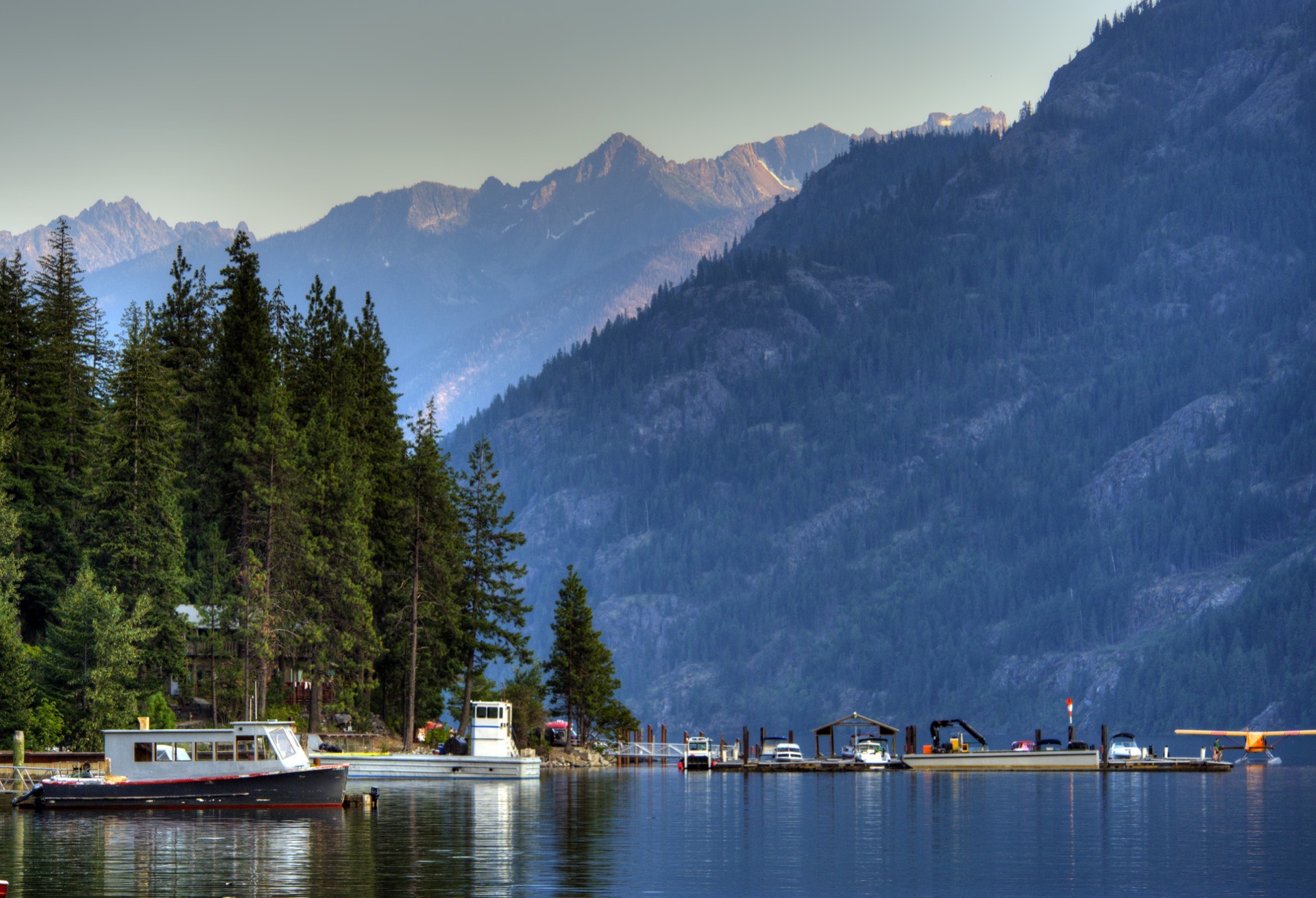
Ross Lake
A 24-mile-long fjord-like lake stretching to the Canadian border, accessible only by foot, boat, or trail — which is precisely why it feels like one of the most remote places in the lower 48. Ross Lake Resort operates a fleet of boats and rents floating cabins; even without staying, day-trippers can boat to the north end and hike to turquoise-blue lakes in the Pasayten Wilderness. The water is cold year-round.
North Cascades Highway (SR-20)
One of the most spectacular 40-mile driving routes in America, this highway climbs from the Skagit River valley through old-growth forest, crosses Rainy Pass (4,855 feet) and Washington Pass (5,477 feet), and descends into the drier eastern slopes. Pullouts at both passes offer views of Glacier Peak, Mount Shuksan, and dozens of other summits. The highway typically opens in late April and closes by November due to snow.
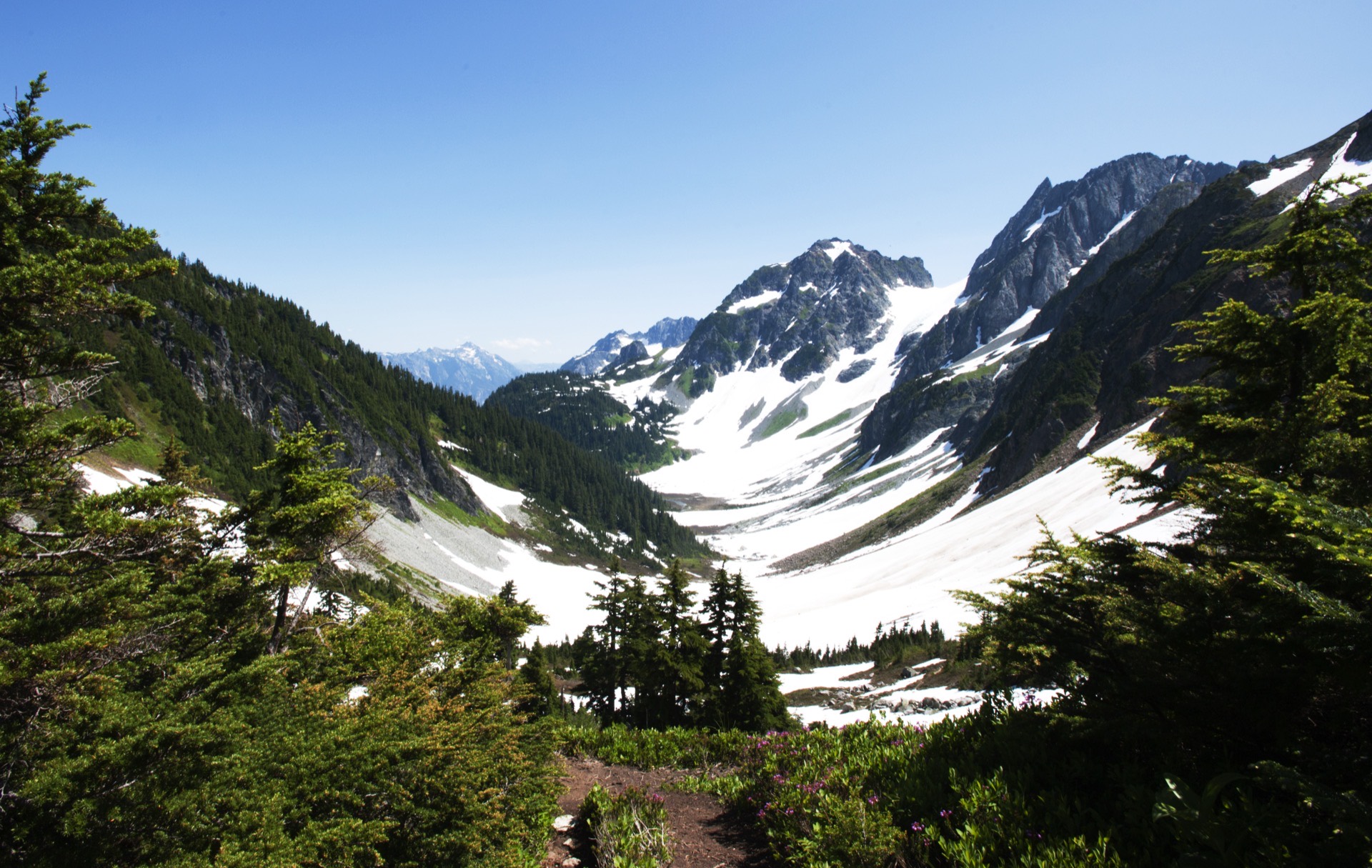
Sahale Arm Trail
A challenging 9-mile round-trip (4,100 feet elevation gain) that ascends to a 8,400-foot saddle with unobstructed views of Mount Rainier, the Stuart Range, and a dozen glaciers. The climb is relentless and steep, but the payoff is standing in a landscape that feels utterly alpine and untouched. Go in late July or August when snow is off the upper sections.
Pickett Range
The park's most rugged and remote alpine cluster, featuring peaks like Mount Fury and Mount Terror (yes, that's the real name) that rise steeply from glaciated valleys. The approaches are long, unmarked, and require scrambling skills; this is wilderness for experienced backcountry travelers willing to bushwhack and navigate via contours. Few people penetrate here, which is exactly the point.
When to Visit
spring
March - May
Spring in North Cascades is a muddy, wet affair — trails at lower elevations are passable, but higher routes remain snow-covered. The real payoff comes in late May when wildflower meadows begin blooming and meltwater creates roaring waterfalls. The North Cascades Highway typically opens by late April, but closures for avalanche mitigation are common. Expect rain, wind, and rapidly changing conditions; this is not tourist season, which means fewer people but also fewer services.
summer
June - September
This is prime time. By mid-July, snow is off most trails, wildflowers are at their peak (especially in the subalpine meadows), and daytime temperatures average in the low-to-mid 70s. The weather is most stable in August and early September. Days are long, crowds are moderate on popular trails like Cascade Pass, and the park feels fully alive — marmots whistling, meltwater rushing, glaciers gleaming in the sun. Bring layers; afternoon thunderstorms are common, and temperatures at high elevations can drop rapidly.
fall
October - November
Autumn brings crisp, clear days and larch trees turning brilliant gold in the high country — the larches are the star here, especially visible from high passes and ridges. Afternoon clouds tend to be fewer, making for sharper mountain views. The North Cascades Highway usually closes by late November as snow accumulates; plan your visit for early-to-mid October if you want guaranteed highway access. Trails at lower elevations remain open well into November.
winter
December - February
The park becomes a backcountry ski and snowshoe domain. The North Cascades Highway closes, and most maintained trails are buried under 10+ feet of snow at higher elevations. Winter mountaineering and ski touring opportunities are world-class for experienced adventurers — the Cascades are famous among ski mountaineers. Lower-elevation trails near the highway corridor remain open. Days are short, storms are frequent and intense, but solitude is nearly complete.
Wildlife & Nature
The park is home to mountain goats that cling impossibly to cliffsides throughout the range — you'll spot them from high passes and ridge trails, their white coats bright against gray rock. Black bears roam the forested valleys and subalpine meadows (keep a tight food cache); mule deer are common in open areas, especially around meadows in late summer and fall. Higher elevations host pikas (small alpine rabbits) and marmots, particularly the hoary marmot, whose distinctive whistle you'll hear on rocky slopes above 7,000 feet. In winter, mountain lions (cougars) descend to lower elevations but are rarely seen. Bird lovers should watch for gray jays, Clark's nutcrackers, and, if you're very lucky, golden eagles soaring over ridge lines. The park's remote reaches are home to wolverines, lynx, and gray wolves, though encounters are exceedingly rare.
Gallery
Photos courtesy of the National Park Service and Wikimedia Commons
Insider Tips
Start the Cascade Pass hike very early (sunrise ideally) from Marblemount on the western side — the parking lot fills by 9 AM on summer weekends, and the crowds thin dramatically when you go early. Plus, morning light on the peaks is incomparable.
The North Cascades Highway is most spectacular in fall (mid-September through early October) when larch trees are golden, crowds have thinned, and afternoon weather is more stable. Skip July and August if you want to avoid the peak tourist crush.
Ross Lake Resort is worth every penny for a night in a floating cabin — it's one of the most surreal places to wake up in the lower 48. Book 6+ months in advance; spots fill quickly. If you can't get a cabin, day-trip by boat from the Diablo Lake area.
Bring a rain jacket and extra layers even on clear days — afternoon thunderstorms roll in fast at high elevations, and temperatures can drop 20+ degrees in minutes. The weather here changes faster than anywhere else in Washington.
Lesser-known gem: the Stehekin Valley on the east side, accessed via Lady of the Lake ferry from Chelan. It's drier, warmer, and far less crowded than the western side. Hike to Cascade Lake or Horseshoe Basin for alpine solitude without the SR-20 crowds.
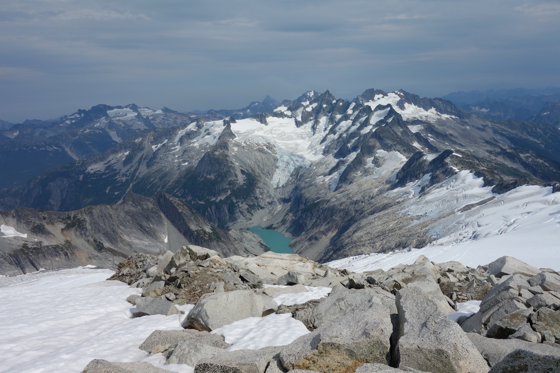
Glaciers are receding visibly — if you want to see them, go soon. Compare historic photos at visitor centers with current views to understand the pace of change. Trails like the Sahale Arm approach still afford closeup views of active glaciers calving into turquoise lakes.